June, 2023
My last day here. Tomorrow morning I head home. I always try to find something I really like on the last day of a camping trip … or I go back to a place that I really liked, that I visited earlier in the week. On this day, I was thinking about a beach again, but didn’t really know exactly where to go.
So I walked out of that Padilla Bay Breazeale Estuarine Center and wandered down a blacktop foot path towards the cliff above the water, just wandering and thinking about where to go next.

Here’s a video of a bit of the walk with bird sounds galore. At the end of the video, you’ll see a white railing that reminds walkers that there is a busy road there and they need to be careful and that the path ends there.
Well not so!
The path does NOT end there!
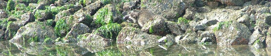
As I got closer, I could see some weird structures.
Take a look at the photo below … with a blue car speeding by on the road.

The path goes under the road! At least, it sure looks like it, doesn’t it? But that tunnel seems like an awfully dark hole.

There were stairs down to that dark tunnel, and there was also a ramp down to the tunnel. That seemed friendly, as if all sorts of people are welcome here. So on I went.

Ah, the long dark tunnel!

As you might have guessed, the far end of the tunnel opened out into gorgeous sunshine again, no danger at all. 🙂 Notice the signs overhead, I’ll show you a couple of them.

The layers of red railings at the end of the wooden walkway prevented you from falling down into a hole … actually, the hole is a circular stairway leading down to the beach. Yay, a new part of the beach! 🙂
But let me show you the view from up here, before I head down that stairway.
Photo below, looking to the right, to the north, all manner of islands. And look how far out the tide is.

And photo below, looking to the left, the southern end of Padilla Bay. And the long, long expanse of tide flats. And yet, in fact, when I was here this day, the tide was not all the way out/low. When the tide is at LOW low, the beach (tide flats) extends more than twice as far out as it did this day when I was here.

Ok, here are closeups of a few of those overhead signs.


Notice the photo on the far left in the sign above, and how much beach there is and that you can’t even see the water. Now THAT’s low tide!
And now it was time to head down the circular staircase. Watch your step!

Down and down and around and around. And finally the last few steps.

Ah, the beach. I love Pacific Northwest beaches. There is so much variety. Some are sand, some are gravel, some are barnacles, some are completely covered in slippery seaweed, some are large rocks. All of them are wonderful.

Here’s a video below of the view, and the sound of my shoes rattling along as I walk on these beach rocks.
I spent time walking or standing or sitting and enjoying the beach, the view out across the tide flats, the smells, the sounds.


Ha! and then I looked more closely at the green seaweed parts … those “auger” shell creatures are on this part of the beach too. They must love the calm water, and the shallow depths of tides such that the water temperature remains relatively warm. There were bazillions of these auger shell creatures here. I counted every one! 🙂

And yet there were also large boulders … the large one below was almost 5 feet tall.

The next three photos are looking south, then directly across the bay to the west, and then to the north. I’ll share a few details of what I’m looking at if you’re interested, but if you don’t want the details then please just enjoy the absolutely wonderful, calm, amazing views on this perfect day.

Above … on the left is the oil refinery, currently owned/operated by Marathon … then the truly lovely town of Anacortes in the center … then the hill called Cap Sante … all on Fidalgo Island. Then there’s some low-lying fog/cloud to the right and behind that fog/cloud is Cypress Island. At least, I think it’s Cypress since I think Guemes Island doesn’t have many hills on it, so that must be Cypress Island.
Next photo (below) looking directly west. Again, I think maybe that’s Cypress Island that we see above the cloud on the left. In the middle of the photo is Hat Island, and ok I bet that’s Guemes Island behind Hat Island, and then Saddlebag Island just to the right of Hat. With just a tiny touch of Sinclair Island above Saddlebag. Then another cloud/fog … and then little Jack Island off to the right.

Next photo (below). Wow, I’m not sure. As I’ve mentioned, I’ve spent most of my adult life on boats out on these waters, NOT looking at things from the perspective of the land. But I think that’s Vendovi Island on the left, and then tall Lummi Island in the middle. And I suspect the closer land mass on the right is Samish Island that I drove to the other day, which is actually accessible by land, by the low spit of land to the right of it.

What fun for me to hang out here on the beach for a couple of hours, walking, exploring, and sitting and looking at the islands and trying to figure them out … but also just breathing and smelling and listening (to the birds, to the rocks, to the squish of mud, to the sound of the water, and the sound of me walking on those gravelly rocks). But eventually, it was time to head back to my big white truck, and then head back to the campground.
Here’s that circular staircase as viewed from the beach … three circles of stairs.


At the top of the stairs (below), that tunnel doesn’t look nearly as menacing as it did earlier.

In fact, I stopped and enjoyed the walk along.

The spring budding blackberry vines.

The luscious green Cedar trees.

And then I dared enter the dark tunnel under that roadway again. I came out the other end of the tunnel no problem and took the stairs here that would lead me back up onto the land with the blacktop walkway and eventually back to the Estuarine Center and back to my big white truck.

What a great find! I hadn’t noticed any signs that told of this beach access, but maybe I just missed the signs. Or maybe the folks here don’t like to advertise this too much. Either way, I had a great time and appreciated the planning and time and effort and money that it took to create this beach access.
Ok, let me go find my big white truck in the Padilla Bay Breazeale Estuarine Center parking lot, and then I’ll drive back to the campground for one last quiet evening in the trailer (Towhee the Trailer) before heading home tomorrow. Sigh. What a perfect day.
What a cool stairway. Did you get dizzy going up or down? Nice beach walk video. 🙂
Good question! No I didn’t get dizzy, Tim, but I sure took those stairs one step at a time, very slowly, since each stair step is very narrow near the center pole, and one could easily slip or misjudge where one’s foot is. Going up the stairs was much easier. 🙂
That place is very cool! Does the tide come up to the spiral stairs at all? How do you decide where you’re going to camp? Do you go to the same places or always new places?
More good questions! Yes, the tide does reach the base of the stairs when there’s a very high high tide. In the photo (6th up from the bottom) … in that photo, you can see a dark patch along the base of the bottom section of concrete. That’s a result of high tide, mud, sand, debris, muck, etc. But that HIGH of a high tide is unusual, so one could go there pretty much any time and be able to walk on at least a bit of the beach.
Deciding where to camp is another good question, Dawn. Often, I simply wait for a week of good weather and then get online and see what campgrounds have openings (usually from cancellations). There are usually several all around the state, and then I pick from those. I don’t repeat places much, a few, but mostly I go to campgrounds I’ve not been to before, and to general areas that I’ve not been to before. In fact, in the very next blog post, I’ll give a short description of how I pick a particular campsite in any given campground. Keep the questions coming! 🙂
Ah the long dark tunnel!!!! How scary! 🙂 I think we all knew you’d be fine but it was fun reading. But wow on the tides and how far they go out! Is that common in all bays in Puget Sound?
No, that is not common in bays around Puget Sound. In fact, I suspect Padilla Bay might be the only bay that is so incredibly shallow such that the water seems to almost drain completely out of the bay when there’s an extreme low tide. Now, other bays do have low tides of course, and boaters must be careful and check tide charts when entering any bay. In my 28 years of boating here, I’ve seen quite a number of boats grounded, waiting for the tide to come back in, when the owner/operator didn’t check the tide chart. 🙂 Thankfully, I’ve never done that!
I’ve been a boater in Puget Sound all my life and never knew how extraordinarily shallow Padilla Bay is, how far out the tide goes when it goes. I’m looking at the tide charts … there are two really low tides on the 15th and the 16th of this month, Sun/Mon mornings, around 9am and 10am, MINUS tides in fact. There are even lower tides later in the month but they’re at 2am, no thank you. 🙂 Gonna drive up to Padilla Bay on the 15th and head down that spiral staircase.
Rob, that’s a great idea! I might just take a drive up there too. I’m about 2.5 hours away, so I’d have to leave home around 7:30 or 8am to get up there on Monday the 16th for that 10am low tide. I’d have to leave at 6:30 am for the Sunday morning 9am low tide, that’s way too early! 🙂 If you do go, take photos from the top of that spiral staircase. Oh I hope you go.
The tunnel was scary cool. Those stairs were wonderful fantastic. Great blog post that taught me a lot. I’ve lived in Ohio all my life, had to look up tides and how they work, fascinating. Online says that the three larger Great Lakes have tides based on the moon, but they sure aren’t as large (high and low) as saltwater ocean tides! I’m on the south shore of Lake Erie and notice a bit of rise and fall but always figured that was because of rain/dry and/or water removed for crops, etc.
Indeed, I’ve read too that those three larger Great Lakes do have tides based on the pull of the moon (and maybe other things too). The info I’ve read doesn’t mention Lake Erie or Lake Ontario. The 1939 wood boat I owned for 18 years was built in Port Clinton, on the southern shore of Lake Erie. Nice to know you’re somewhere in that area as well, Lisa. 🙂
So, it seems like a lot of expense to build that tunnel and the spiral staircase. Do people use it? Was there anyone else there when you were there? I look at Google Earth and it seems there are other easier ways to get down to the beach by car and/or by foot. Just seems odd that this extraordinarily wonderful place isn’t used and isn’t advertised … what do you think? Any hints on why it was built and yet not advertised?
I love how you tell the story of places. 🙂 Feels like I’m right there with you.
More good questions! Thanks, Babe. 🙂 Today I spent a good bit of time online trying to find out the history of that spiral staircase and I can’t dig up any info on it … history or funding. There is a Padilla Bay Foundation online … contacting them might reveal some answers, but there was no information online except to note that the spiral staircase is there, along with the tunnel under the roadway.
Thanks for the nice words. 🙂
Boater, me too. Never been in Padilla Bay either and now I know why! ha! No water at low tide. But wow it’s gorgeous and what an exceptional, one-of-a-kind bay. Maybe they don’t want people traipsing all over the eel grass and destroying the environment, so that’s why they don’t advertise it? There really is nothing else like this in Puget Sound.
The photos of the islands are beautiful, and I think you named them correctly, far as I can tell. 🙂
Yes, one-of-a-kind indeed. I think all of us boaters were surprised to learn about how shallow, and yet how big (wide and long) Padilla Bay is. If we took our boats in there at high tide, we’d never have guessed that our boats would be sitting on eel grass and mud a few hours later. I bet you kept your tide charts handy just like I did, Mark. Thanks for your encouragement in my naming the islands. I later checked on Google Earth and think I named them correctly. But either way, it was fun to do. 🙂
Wonderful. Thank you. Please never stop. 🙂
Thank you Judy. 🙂 Ok, I’ll never stop.
We have “Marathon” gas stations here, so I looked them up online and it’s the same company that owns that oil refinery where you are, same logo, same company. The gas prices at Marathon stations here are 20 to 30 cents less per gallon than any other gas stations here. And no wonder! They own and refine the gasoline (and probably diesel too) and then there is no middle-man (or two or three) to add to the cost at the pump. I sure have mixed feelings about all of this. I use gasoline, wish I didn’t. But that was interesting about “Marathon”.
Kinny, after I read the replies here today, including yours, I drove to the grocery store and noticed a Marathon gas/diesel station where I live too. I’m glad you mentioned it! And yes, the price at this local Marathon station was significantly less than at any other gas station in the area. I may have to check it out! My big white truck does burn a bit of gasoline so maybe I could save some money. I too have mixed feelings about all of that. It’s hard to know what to do.
I’ve been over the hill to western Washington a few times but usually to Seattle and not to see much of anything else. This was fantastic. That Bay View area and up the Chuckanut seem like a perfect place to visit one of these days.
Oh there’s so much to see over here, Paul. Come spend a weekend or a week. Bring family, bring a friend, rent an RV and come camping … or come to Seattle to visit/see whoever you see there, and then just walk onto a ferry (taking a vehicle is expensive). Best one from Seattle would likely be the ferry to Bremerton as it winds its way north of Blake Island, and south of Bainbridge Island. There are things to see and do in Bremerton for a couple of hours while you wait for a later ferry to take you back to Seattle. Or come stay in the Mount Vernon area and drive the Chuckanut.
I’ve been camping in the Yakima area twice now … there’s such great stuff to see and do over where you live! I’ll be back. 🙂
I notice you travel mostly by yourself, tho you are in campgrounds with other people, but you are often out hiking or exploring on your own. When I was a young guy, I never thought about hiking out into back country by myself, but as I got older, I had concerns. I still go (I’m 71), but now I always let someone know where I am if I’m alone and, actually, I almost never go back country camping alone anymore. How do you feel about those issues? When you started down that spiral staircase and I realized there wasn’t anyone else around, I got nervous! What if you fell? What if some dastardly person was down there? I’m not asking this of you because you’re a woman … I felt fearful, for me if I’d been there! I would have hesitated! What do you think?
Great blog, I love all of the stuff you post. 🙂
Oh, good question, Steve! I’m 76 and very much aware of my age and the possibility of reduced eyesight, balance, hearing, judgment, etc. So far I’m extremely healthy, but it is absolutely something to keep in mind. When I’m hiking/walking by myself in the woods or on a beach, I always have a fully charged cell phone in my pocket, and I have water and food with me, and a note in my pocket that says where I’m camped and my emergency contact friends, just in case. AND when I’m in the woods, I carry wolf urine in a spray bottle (thank you Tim in Montana) which a heck of a lot of people tell me is better than bear spray for deterring bears and elk and cougar, etc.
On the other hand, if there is a dastardly human somewhere, that’s another problem. I guess I spray them with wolf urine and it stinks so bad that maybe the human will run away. I do keep this in mind but, in the end, I try to pay attention, look around (I waited at the top of that spiral staircase awhile, just looking around, not just to take photos, but to scope out “things” below). And, in the end, I go, after being careful. If I fall, all on my own, then I hope I can use the phone to call for help, or I hope someone will come along and help me. Accidents can happen to someone in their 20’s too. So far I’m blessed with good health, so I’m careful, and I’m going!!
Thanks for being here and for commenting. 🙂